

The National Hurricane Center (NHC) has raised concerns about a developing storm system in the Atlantic that could potentially threaten Florida.
This system, which currently has a 40% chance of developing into a named tropical storm, could be designated "Chris" if it reaches that stage.
The storm is forming as a tropical wave moves across the Leeward Islands and the Greater Antilles, areas that often act as critical indicators for storm paths towards the southeastern United States.
The NHC's advisory highlights that conditions are becoming increasingly favorable for this system to strengthen into a tropical depression by mid to late week, potentially bringing significant impacts to Florida and surrounding regions.
Current Weather Conditions
The system in question is presently marked by a region of disturbed weather that is interacting with an approaching tropical wave. This interaction is crucial as it can enhance the system's structure, possibly leading to the development of a tropical depression or even a named storm.
According to the NHC's Tropical Weather Outlook, the system has a low chance of formation within the next 48 hours, but the probability rises significantly to a medium chance over the next seven days.
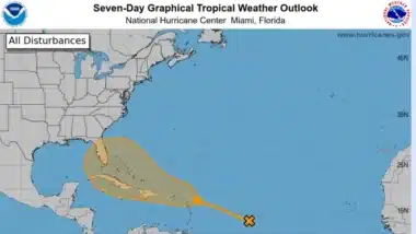
The potential development area extends from the northern Leeward Islands to the southwestern Atlantic Ocean, a region currently affected by Saharan dust.
This dust can often inhibit storm development by drying out the atmosphere, but in this case, there is sufficient moisture present to potentially counteract this effect, facilitating the system's growth into a tropical cyclone.
Possible Impact and Forecasts
The possible paths for this developing system are varied, ranging from moving east of Florida to entering the Gulf of Mexico, or even dissipating over the mountainous regions of the Caribbean.
The presence of Saharan dust is a complicating factor; while it generally acts as a suppressing agent by introducing dry air into the storm environment, there are also areas of enhanced moisture that could support the storm's intensification.
Should the system develop into a tropical storm, it could bring significant rainfall, strong winds, and potentially hazardous weather conditions to affected areas. This makes it crucial for residents and authorities to monitor the situation closely and prepare for possible severe weather.
Seasonal Outlook
This potential storm development comes after a relatively inactive period in the 2024 hurricane season. However, meteorologists have warned that the quiet spell may not last, as this season is expected to be particularly active.
The recent activity of Hurricane Beryl, which became the earliest Category 5 hurricane on record for the Atlantic, has heightened concerns.
Beryl's rapid intensification and the record-setting nature of its formation—farther east than any previous June hurricane—have prompted meteorologists to predict an increased likelihood of major hurricane landfalls along the U.S. coastline and in the Caribbean.
Colorado State University has updated its forecast to predict up to 25 named storms for the season, an increase from the initial projection of 23. This forecast is based on current atmospheric conditions, including warmer-than-average sea surface temperatures and other factors conducive to storm development.
Experts are urging residents in potentially affected areas to remain vigilant and prepared for what could be a particularly challenging hurricane season. The combination of favorable atmospheric conditions, including high sea surface temperatures and conducive wind patterns, suggests that the Atlantic is primed for an active period.
The NHC and other meteorological organizations will continue to monitor the developing situation closely, providing updates and advisories as more information becomes available. Given the potential for rapid intensification, as seen with Hurricane Beryl, residents are advised to have emergency plans in place and to stay informed through reliable news sources and official channels.
